 Live Music Archive
 Librivox Free Audio
 Metropolitan Museum
 Cleveland Museum of Art
 Internet Arcade
 Console Living Room
 Books to Borrow
 Open Library
 TV News
 Understanding 9/11
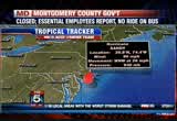
tv Fox News Edge Special Edition FOX October 29, 2012 6:30pm-7:00pm EDT
6:31 pm
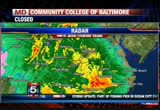
thanks a lot bryan. if you just stepped outside, the rain is not all that bad, but we did want to show you that there's a heavier band coming across. >> yeah, this is capable of going way along and grabbing some big wind, so some sprong winds coming across the bay and saint mary city and the park and that next band in the pipeline will likely be able to once again produce some gusts up to 60 to 70 miles an hour. dc get ready. this is going to be moving in your direction very very shortly and looks like it is. that's the first heads up. we're showing you the rain or
6:32 pm
how much will be falling. this is anywhere in an inch an hour as the bands are moving in. so we are about one-third of the way of five inches of rainstorm total, by the time it wraps up. >> yeah, in terms of rain fall totals, we will switch over and be able to see what we're talking about here. we remain and continue to see the highest totals being out to the west of us and just crossing over to the western show here for the county and then here in town we have been around three and a half inches and furtherer to the north the heavy rain bands are not over there. we see the rain fall basically transition to lower amounts from east to west and that's what we would anticipate to see
6:33 pm
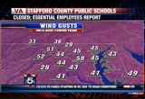
with this type of situation. >> at the hour it's 58 miles an hour. that was at 6:00 and fredericks have a wind gust at 41 and we still see a 51 an hour mile gust in martins burger. >> i am beginning to think that there's something wrong with the frederick station. i am going have to investigate that. usualablely it does a good job and tells you what it does. >> yeah, this is a model product that we use to show us where the center of circulation is right now and how the direction represents where the wind is coming from. >> notice that it's tithely packed here. this is a model forecast and projecting the atmosphere to do. you see the center that it
6:34 pm
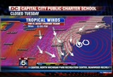
projected where the center of sandy would be. this is not going to work, but it's in here. i grabbed the wrong thing. that's where the model said it would be. the actual center is about there. so probably five to 75 miles to the south and south west. that's a bulls eye. notice that it's pulling and that helps us with the bay and even helps some of the shore beaches because they are not getting all of that on shore flow. they are not getting the big storm surge issues here. take this into time and notice by tomorrow at noon the bars are beginning to relax a little bit and the wind is beginning to relax a little bill of indictment the direction is going to be switching a little bit. >> yeah, then we get a little bit of wind up the bay. i would watch minneapolis more
6:35 pm
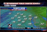
tomorrow to see what happens and some of these maybe blown out, but there's a little more water piling as the wind goes to the south and ought west. >> yeah, along the eastern shore there's some issues there and then by tomorrow evening the storm will continue to lift and it will help us out a bit. >> much more wind pattern but the cold weather is another story and cold out there. >> 46 degrees and it's a little colder for winchester. >> you need to go north to if you want to see it. >> we have a 32. >> yeah, the storm is pulling in cold air from the north and the west, so what is out of canada is just everything being sucked into the storm in all directions and interestingly enough new york city and boston on the northern side, so they
6:36 pm
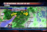
are bringing in the wind from the ocean temperatures. so their temperatures are a little bit warmer because the winds are coming from the south and south west most of the day. >> that's why the storm is so -- it's a tropical system that's coming across the area and making a new storm all together. a couple of changes with the future cast. we know that we're going to have some heavy rain and the snow will continue and we will have rain continuing and over night and until the first part of tuesday. notice that the snow stays off to the west and maybe a little bit sneaks into the area and by 5:00 and through tomorrow afternoon we're through the pattern. the worst of this will be over and we will don't to prove by the time that we get to the noon hour. still going to be a long night as we continue with the peak
6:37 pm
continues between now and 3:00 and 4:00 in the morning. >> yeah, it does look like 10:00 p.m. and 2:00 a.m. is when the winds will be at their peak okay. we will send it back up to bryan and shaun. >> okay. >> we will go back to ocean city and we have been talking all afternoon about pier and now the pier is in the bay and it has broken off into the ocean as well. that's confirmed by the twitter feed. the pier fishing pier at ocean city snapped in half. a live report from the other side. [ mitt romney ] we have toto work on a collaborative basis.
6:38 pm

look, the reason i'm in this race is there are people that are really hurting today in this country. and we face this deficit -- could crush the future generations. and republicans and democrats both love america but we need to have leadership -- leadership in washington that will actually bring people together and get the job done and could not care less if it's a republican or a democrat. i've done it before, i'll do it again. i'm mitt romney, and i approve this message.
6:39 pm

i'm mitt romney, my name is julian bond. i know a little something about fighting for what's right and just. maryland's gay and lesbian families share the same values and they should share in the right to marry. i believe people of faith understand this isn't about any one religious belief. it's about protecting the civil right to make a lifelong commitment to the person you love. join me in supporting question 6. it's the right thing to do.

6:41 pm

this is 59th and the bay in maryland. as the night fell you can see the rains come and then they picked up. watch as daybreaks and you see the water taking on. well, there's one and that's where it stops. there's one carcinoma see bo to the right and it's broken off and at a complex and this is the island and this is theirs and a lot of people go and listen to the 18th over which are. getting the name right. it's as the sun set goes down. 44 minutes ago officially. if anybody sees it, please point it in the direction of home. it appears that it has broken off into the bay. just a traffic city and we're on lock down as everybody is because the water is coming in from all directions and the ocean is pouring into down by
6:42 pm

the inland on to the coastal highway and the bay as we have seen from 2:00 this afternoon it had reached 33 street and in that little island of the barrier island is sherry and she is at 16th street and the board walk and i know that you're not getting so see a lot of these pictures because you can't get out but daylight is going to be crushing. >> reporter: it is. it's going to take day light for the town to get out there and the damage. they are in the emergency operation center that's operating 24/7 right now. they are getting the same reports that we are. they are not going to be going out and looking at the damage and i have to tell you that it's dangerous. there's all kinds of stuff around here. this is a light fixture that just blew off and crashed about four feet away from where i was standing.
6:43 pm
a very dangerous situation. that's one of the reasons that they are telling people that they need to shelter people and stay inside and don't come out here and look at the waves no matter how large that they are and exciting that it might seem to you. this is a very dangerous situation. we're starting to see the water come up and crash over the sea wall here and seeing some minor flooding along the board walk ane of what gary was talking about where the winds are sort of coming off the large waves and that's helping to keep that water back from the ocean and there's significant damage and not only the water coming and businesses along the board walk and most of them a little furtherer north of here, but the southern section of the town is amount underwater. a lot of the streets are flooded. flooded homes on that side. we're seeing damaged to the pier and half the pier 150-foot
6:44 pm
section washed away and the pounding that it's taken from the storm. we have both bridges into the town and out that are shut down only emergency vehicles are being allowed to go across or come into town. so pretty much everybody here is stuck. you need to stay inside and ride out the storm. now, there are a number of people that did not heed the warnings in that downtown area from 17th street south and we're hearing today that the town had to have some emergency responders go out and get some of the families not only in that mandatory area but along the bay when the water started to rise and it was too dangerous. the families wanted out and they were able to go and evacuate 20 to 30 families. as of right now, both the route 50 and 90 bridges are closed.
6:45 pm

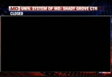
you cannot get out of here. all the roads around here are also closed to traffic because there's so much flooding. many of these streets are impassable. it's a very dangerous situation out here. the winds are high and it's going to continue for several more hours. that's the latest here in ocean city. back to you. >> thanks. >> thank you very much. i want to give folks some good news with all the bad that's coming in. montgomery county library is closed tomorrow but if you owed fines, they have been waved and the same thing with tickets through dc's dmv. if you owed, you have a little grace period between october 29th and november 1st. those that want to see x factor will be on my 28. we will be right back. president obama: there's just no quit in america...
6:46 pm

and you're seeing that r now. over five million new jobs. exports up forty one percent. home values... rising. our auto industry... back. and our heroes are coming home. we're not there yet, but we've made real progress and the... last thing we should do is turn back now. here's my plan for the next four years: making education and training a national priority; building on our manufacturing boom; boosting american-made energy; reducing the deficits responsibly by cutting where... we can, and asking the wealthy to pay a little more. and ending the war in afghanistan, so we can... do some nation-building here at home. that's the right path. so read my plan, compare it to governor romney's... and decide which is better for you. it's an honor to be your president... and i'm asking for your vote... so together, we can keep moving america forward. i'm barack obama and i approve this message.
6:47 pm

athat's what the plan georged allen supports... would cost our economy. newspapers called it "economically destructive." like allen's votes to give tax breaks to companies... that ship jobs overseas, his economic plan would... help big corporations, devastating the middle class. allen even voted against tax breaks for small businesses. virginia can't afford to go back to george allen. the democratic senatorial campaign committee... is responsible for the content of this advertising.
6:48 pm

look, the reason i'm in this race is there are people that are really hurting today in this country. and we face this deficit -- could crush the future generations. and republicans and democrats both love america but we need to have leadership -- leadership in washington that will actually bring people together and get the job done and could not care less if it's a republican or a democrat. i've done it before, i'll do it again. i'm mitt romney, and i approve this message.
6:49 pm

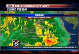
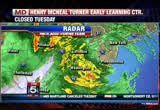
welcome back to the continuing coverage hurricane sandy. some breaking news maryland health is saying that one person died somewhere in montgomery county. we're trying to find out what happened. one person has died in a storm related crash. >> you have to take the roads slow. as of this morning and heading to your neck of the woods and 95 and the belt way and going up 270, there were three crashes, so you know it's going to get worse. >> yeah, it's hard to drive with a gust and the outer bands hit you with the heavy rain and the gusts up to 60 miles an hour. a lot of flooding and you combine that with the darkness and leaves that have to be done. it's slipperily and dangerous
6:50 pm
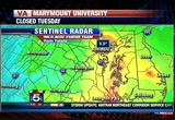
and hard to see. i know that we see this over and over but don't travel if you don't have too. that's why. we don't want to add to fatalities. it's hard enough to stay out of harms way if you don't have to travel. over on radar we go over to show you another big band is in the process of coming in. i will put the whole thing in motion and getting a little closer and that's another band that could potentially put down some rain and that's coming inside the belt way and it's crossed the beach area and it's going to be spreading down to rest tin and deal city. so that might have some winds gusts as well. you can see the whole as we look at the where the storm is likely now approaching that land fall on the south jersey
6:51 pm
coast. we should have an update here on seven or eight minutes. they will give another update and see if it's on shore. a lot of that heavy rain is on shore. i want to show you that not only can you see the snow because of the really cold air, but look at how the outer band is already in the cleveland area. a friend of mine that works up there says that they had 20- foot waves. so it's doing a number here on a number of states. we have not mentioned this in a while but snow is a likelihood as abelias saturday warning is up for elevations above 2,000 feet and that does include the county area and that gets down
6:52 pm
into madison and page and green where that very heavy wet snow the globe is going to stick to everything and bring down trees and lines. it's a cold mess out there and maybe even a little bit of it mixes in, but this storm has so many aspects to it, and winter is one of it. here is the last update and storm is hurricane sandy is still a hurricane and strong category cat one and nearly a two. had some forward motion to it to the north-northwest but we believe that it's going to slow down with the leading edge of the colder air and may take a little bit longer to pass to the north and dropping the heavy rain and some of that
6:53 pm
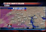
could result in according to the national weather service the kind of flooding that we may have seen back in 1996 only because it has not hit the base and we will be able to maybe pass by some of that. it takes a turn up through new york state and we will still be talking about it. at the moment the highest wind gust is 58 miles an hour. we have a 53 a mile hour gust and 51 in martins burger. we go over to the coast and 56 at ocean city and is that an 82 that i am seeing? yes, it is. 82-mile an hour wind gusts. wow. but that's the highest that we have seen. so yeah that's hurricane sandy and creating a huge problem just a nightmare for new york. we will have some pictures to show you out of new york city
6:54 pm

here. we will have an update from the hurricane center at the top of the hour. >> just a quick reminder, if you have pictures or video send them to my weather photo. >> we will be right back. president obama: there's just no quit in america... and you're seeing that right now. over five million new jobs. exports up forty one percent. home values... rising. our auto industry... back. and our heroes are coming home. we're not there yet, but we've made real progress and the... last thing we should do is turn back now. here's my plan for the next four years: making education and training a national priority; building on our manufacturing boom; boosting american-made energy; reducing the deficits responsibly by cutting where... we can, and asking the wealthy to pay a little more.
6:55 pm

and ending the war in afghanistan, so we can... do some nation-building here at home. that's the right path. so read my plan, compare it to governor romney's... and decide which is better for you. it's an honor to be your president... and i'm asking for your vote... so together, we can keep moving america forward. i'm barack obama and i approve this message. would ban all abortions and contraception seemed a bit extreme. so i looked into it.
6:56 pm

turns out, romney doesn't oppose contraception at all. in fact, he thinks abortion should be an option in cases of rape, incest, or to save a mother's life. this issue's important to me, but i'm more concerned about the debt our children will be left with. i voted for president obama last time, but we just can't afford four more years. [ romney ] i'm mitt romney and i approve this message.
6:57 pm

welcome back everyone to the continuing coverage of sandy and of course we're continuing to watch the storm as it starts to come ashore near atlantic city and we understand that the national weather service says that it's holding winds in some areas of 90 miles an hour. >> we are also getting a lot of reports that the power is going out. we have been reporting on since we came on tonight and we have
6:58 pm

seen that there are numerous but the numbers are starting to ramp up. the wind is going to keep bending and bending on the trees and eventually the trees will break and some of those lines will go down. >> we want to go to where a lot of folks head in this area. sherry is live in ocean city. sherry, it looks like the calm is coming now before the storm for you you. >> reporter: it is. we seem to be in one of these bands and one is past us and i am sure that we're going get hit by another one. it's a little bit of a welcome and given the pounding that we have taken here all day long. this is extensive damage throughout ocean city and the entire town prety much is sealed off. you can not get out or in. the bridges have been closed
6:59 pm

expect for emergency vehicles. the streets are flooded and we have homes that are flood and if you look at the ocean you can see this huge storm surge that's coming in. this is the time that the town said that they expected to have the worst of sandy coming through and we're seeing it. one thing that is sort of saving the beach here is the winds seem to be sheering off a little bit of the waves and holding them back. we're still seeing over wash on to the board walk. it's the same thing that we saw on high tide earlier this morning as well. through the streets we're seeing a foot and a half of water and we're seeing two, three, four feet along the bay. really this entire town is being hit from both sides with flooding. you have the water coming in off the ocean from that storm and then the waters are rising from the bay as well. the town is telling everybody at this point to
103 Views
IN COLLECTIONS
WTTG (FOX) Television Archive
  Television Archive News Search Service
Uploaded by TV Archive on
